Monitoring Myanmar Flooding
18 September 2015, Geneva, Switzerland - Following a heavy monsoon season in Myanmar this year, UNOSAT worked in collaboration with the United Nations Development Program (UNDP) Myanmar – amongst other partners – to analyze the seriousness of the situation and give accurate and timely data to support humanitarian deployment efforts locally. UNOSAT analysts and local teams are still working hand in hand to help people affected by flooding waters.
The Situation
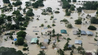
Starting early July, torrential monsoon rains incessantly poured over Myanmar, leading to severe flooding and affecting twelve of the country’s fourteen states. The extreme rainfall affected about one million people. Even though Myanmar faces flooding every year due to its monsoon season, 2015 was particularly intense and led to an emergency situation. UNDP Myanmar and the Myanmar Information Management Unit immediately activated UNOSAT’s rapid mapping service to better assess the damages and thus allocate the right resources to the right locations. The satellite imagery based analysis offered a holistic overview of the flood situation, which is often difficult to get from field data or secondary data collection.

UNOSAT ensured coordination of the satellite mapping activity as part of the Global Disaster Alert and Coordination System (GDACS), including identifying gaps together with the EC Copernicus programme.
UNOSAT’s Rapid Mapping Service
UNOSAT is a technology intensive programme delivering imagery analysis and satellite solutions to relief and development organizations within and outside the UN system to help make a difference in critical situations. UN sister agencies and humanitarian entities operating in line with UN policies can request the rapid mapping service for free (watch a video on rapid mapping service to see how it works).
In this case, UNOSAT experts analyzed satellite imagery from different sources to produce maps and data that can be easily understood and used by people on the ground, providing vital information on the magnitude and locations of the flooding. The UNOSAT team worked closely with partners locally to provide the necessary information on time for humanitarian efforts underway. As mentioned by Einar Bjorgo, UNOSAT Manager: “This support is a good example of our longer term monitoring capacity of flood events, where we combine imagery received using our own Imagery Fund as well as the Space Charter1.
This support is a good example of our longer term monitoring capacity of flood events
Requested by the Office for the Coordination of Humanitarian Affairs (OCHA), UNOSAT also published online a Live Map of the flooding, integrating results from various sources to monitor flood waters. Particular focus was put on information derived from satellite imagery and field data, which allows for a very fast update every time new information is made available.
What is happening now?
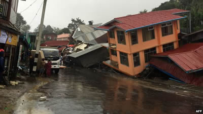
After a period of stabilization in late August, more flooding occurred in early September, leading to significant landslides in the country and requiring UNOSAT to concentrate once again on producing new maps for the region. Our goal is to make satellite solutions and geographic information easily accessible to experts who work at reducing the impact of this disaster and thus UNOSAT will continue to provide timely and high-quality geo-spatial information as long as needed.

Photo1: Aerial view shows the flooded area of Kalay, Sagaing Region, Upper Myanmar, Aug. 1, 2015 (photo:AFP/Sai Zaw)
Photo 2:Apartments are destroyed following a landslide in Harkhar, Chin State of Myanmar, July 30. (Photo AFP)
Interested in UNOSAT work? Follow us on Twitter and Facebook or visit https://www.unitar.org/unosat/
[1] The International Charter on Space and Major Disasters www.disasterscharter.org aims at providing a unified system of space data acquisition and delivery to those affected by natural or man-made disasters

