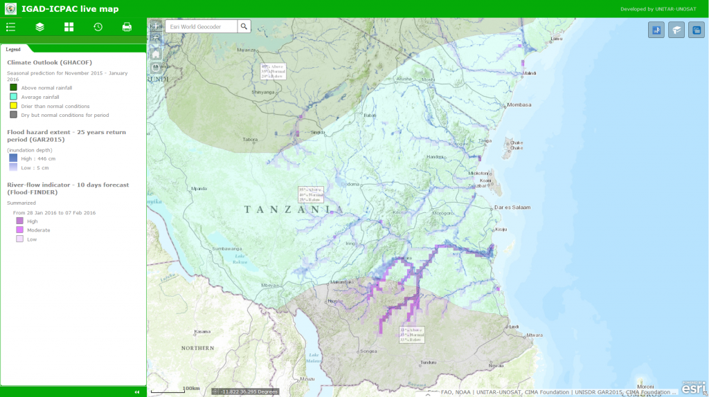
Live Web-map to monitor Climate and Associated Hazards in the Greater Horn of Africa
Nairobi, 27 January 2016 – With the aim to further improve accessibility to information on climate and hazard data, the Intergovernmental Authority on Development (IGAD) Climate Prediction & Applications Centre (ICPAC) has published a live web-map to monitor climate and associated hazards in the Greater Horn of Africa region. With technical support from UNITAR’s Operational Satellite Applications Programme (UNOSAT), IGAD-ICPAC’s GIS experts developed this comprehensive map that include multiple layers of information related to climate, flood hazard and changes in vegetation conditions all constantly updated to ensure timely information is available to all stakeholders simultaneously.
UNOSAT and IGAD
Both organisations have a long-standing collaboration to strengthen technological capacities for Disaster Risk Reduction (DRR) among IGAD member states and within the centre itself. This initiative, a multi-year programme funded by the Government of Norway, aims at increasing capacity of IGAD and its member states to perform in-house geospatial analysis, mapping and data sharing in support to disaster risk reduction and early warning; implementation of this initiative is coordinated by ICPAC in collaboration with UNOSAT’s team in Nairobi and Geneva.
The activities focus on knowledge transfer, on the use of geospatial information technologies at technical level, awareness raising at policy-making level and technical backstopping for improving services and data delivery. The publication of this live web-map responds to the increasing need to improve climate services and information sharing among a wide variety of technical and non-technical stakeholders. In addition, a geo-portal for hosting a wide variety of DRR-related geographic data is also available at ICPAC.
The live web-map

The live web-map is presently composed of 7 geographic data layers displaying accumulated rainfall, Seasonal climate outlooks, flood hazard, flood risk and river flow indicators, as well as NDVI (normalized Difference Vegetation Index) anomaly analysis, satellite flood analysis and photos from the field. All layers are regularly updated to ensure that the live map shows the most up to date information; the map combines data from ICPAC,UNOSAT, CIMA Foundation, UNISDR’s GAR 2015, and NASA.
This live web-map is an innovative product as it allows for a comprehensive monitoring of the climate conditions in the region; In particular, the flood risk indicator and the river-flow indicator layers are produced using a flood modelling tool that provide forecast information by creating simulated flood scenarios for forecasts 10 days in advance. The map also includes seasonal climate outlooks resulting from Climate Outlook Forums and analyses of vegetation changes updated with the most recent data available through Global Agricultural Monitoring (NASA/GSFC/GIMMS).
Availability of climate and hazard information is becoming increasingly important for many sectors, such as agriculture, water management, economy and trade. Accessing up-to-date information is crucial in a time where climatic phenomena, such as El Niño, destabilize normal seasonal patterns.
Official Launch
ICPAC will officially launch this live web-map during the 42nd Greater Horn of Africa Climate Outlook Forum (GHACOF 42), on 22-23 February in Kigali, Rwanda: however to ensure immediate impact the live web-map can already be accessed online on ICPAC website here. ICPAC and UNOSAT welcome any suggestions for improvements: please send your feedback to jouma@icpac.net and/or valeria.drigo@unitar.org
Related Links
IGAD-ICPAC Live-Map
ICPAC Geo-Portal
UNOSAT website
IGAD website
ICPAC website

