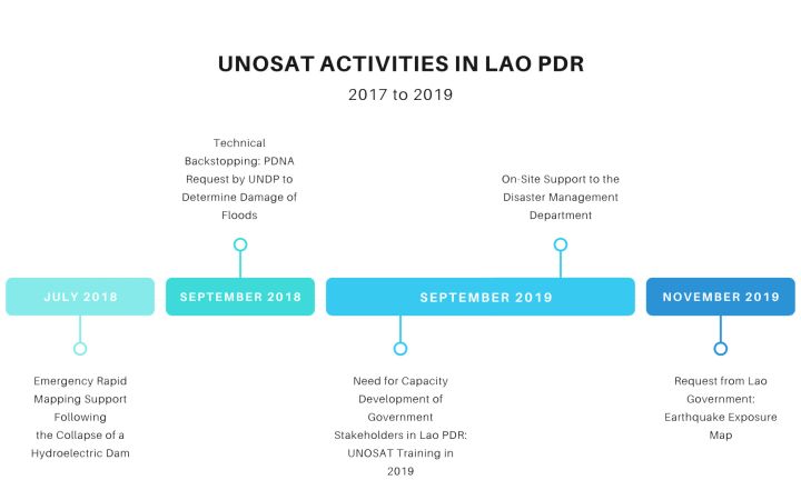
December 2020, Geneva, Switzerland – Between 2017 and 2019, UNOSAT has been committed to supporting the Lao People's Democratic Republic (PDR) to build resilience to the many hazards the country is exposed to, namely floods and tropical storms – hazards which will only grow in severity and frequency with climate change. The situation is especially urgent as Lao PDR is particularly vulnerable to these threats, as it is ranked one of the poorest or least developed countries in the Asia Pacific region. Thanks to the financial support from the Norwegian Agency for Development Cooperation (NORAD) and the Norwegian Ministry of Foreign Affairs, UNOSAT has been able to provide its rapid mapping service, technical backstopping activities, and trainings in the country between 2017 and 2019.
Due to the tropical climate and the unique topographic characteristics, Lao PDR is exposed to a range of hazards that often results in devastating catastrophes. More than 80 percent of its population lives in rural areas in vulnerable conditions where two-thirds of them rely on agriculture. In recent years the country is experiencing devastation from flooding almost every year. In addition to this, Lao PDR suffered from a 6.1 magnitude earthquake in November 2019 and, according to global hazard assessment systems, the country is exposed to medium seismic hazards, which is likely to translate into high risk due to vulnerable buildings and infrastructure. UNOSAT has provided rapid mapping services for the 2018, 2019 flood, and 2019 earthquake, but the post-disaster information can only be fully utilized for smart decision making when operationally integrated into different relevant ministries workflow.
Emergency Rapid Mapping Support Following the Collapse of a Hydroelectric Dam in 2018
Since the beginning of the latest project period, UNOSAT has been assisting Lao PDR and the operations of fellow UN agencies in regards to disaster response. Active support took off in 2018, following the collapse of the Xe-Pian Xe-Namnoy hydroelectric dam on 23 July 2018, caused by unusually heavy rain brought on by the dual threat of the monsoon season and the onslaught of Tropical Storm Son Tinh. The ensuing flash floods affected over 16,000 people in the Sanamxay District of Attapeu Province.
An initial request by the World Food Programme (WFP) the next day, sought UNOSAT’s Rapid Mapping Service to provide satellite imagery analysis to support the humanitarian response in the country’s southern province. UNOSAT triggered the International Charter on Space and Major Disasters obtaining – within two hours of the request – post-event radar images analyzed to highlight the effects of the dam collapse.
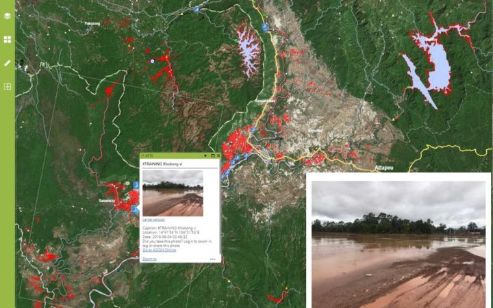
UNOSAT’s analysis revealed an increase in inundated areas and villages located downstream of Saddle Dam D, as well as a reduction in water level and size of a reservoir controlled by the dam. Subsequent emergency response products were provided to monitor the evolution of detected flood water extent and the potential impact on villages.
All results were shared in a timely manner with the government of Lao PDR through the United Nations Economic and Social Commission for Asia and the Pacific (UNESCAP). Through the Lao PDR National Focal Point, the Regional Space Applications Programme for Sustainable Development of UNESCAP gathered ever-evolving country information needs and ensured effective distribution of products. The National Focal Point was grateful for the satellite imagery derived insights over the areas affected by water floods.
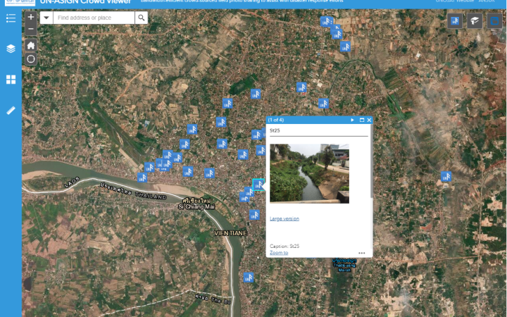
Additionally, a live map integrating various types of data (including UN-ASIGN field photos) and the most up to date satellite analysis were made available to bolster humanitarian efforts, with further products provided to ensure proper follow-up of the situation for disaster recovery.
Technical Backstopping: PDNA Request by UNDP to Determine Damage of Floods
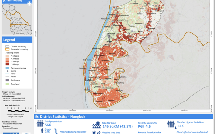
Effects of the floods were still felt weeks after the collapse of the dam. In mid-September, upon request from the Government of Lao PDR and the United Nations Development Programme (UNDP) country office, UNOSAT’s Asia-Pacific regional office carried out big data analytics to determine the damage due to flooding. This supported the UNDP-funded Post Disaster Needs Assessment (PDNA), in particular, because UNDP saw the need and recognized the benefit of additional imaging facilities for the identification of the exact locations, duration, and impacts of the flood event. The technical backstopping project had two main requests, the first on identifying flooding extent with timeline, and second on identifying potential damages from flooding to support the PDNA field missions. The analysis results and emergency response products assisted in setting the baseline for the PDNA analytical assessment and support activities.
In an interview with Shairi Mathur, a Programme Specialist at UNDP who works in crisis response and recovery, she stated that her team frequently conducts PDNAs, commenting that “the use of geospatial data provided [them] with a baseline to better communicate the extent of the disaster to national stakeholders”.
The data and imagery provided by UNOSAT for the UNDP-mandated sectors of the PDNA proved to be very useful in representing damage and loss by province, and per capita, as well as in providing sector-specific assessments, such as analysis on the flood’s potential impact on unexploded ordnance (UXO).
This partnership has been innovative in many ways, including the targeted use of geospatial information in a PDNA as well as the cross-sectoral nature of the application, and engagement with several agencies. UNDP Country Office is interested in an on-going partnership with UNOSAT beyond this PDNA, towards future Disaster Recovery Framework (DRF) or Action Plan stages, to receive additional layers on other hazards (e.g., seismic, drought, landslides) as these are necessary to consider when targeting multiple recovery efforts.
Need for Capacity Development of Government Stakeholders in Lao PDR: UNOSAT Training in 2019
While activities for the PDNA were underway, it was soon realized that there was a need to further build the capacity of Lao government stakeholders on the analysis of geospatial data and satellite imagery.
To prepare for challenges brought on by natural hazards, Geospatial Information Technologies (GIT), including satellite imagery analysis and remote sensing, play an essential role in understanding the geographic extent and severity of challenges at stake, thereby improving strategic planning processes for emergency response and recovery. Thus, UNOSAT’s technical trainings seek to enhance the capacities of stakeholders to process and understand geospatial information for evidence-based operational planning and decision-making for Disaster Risk Reduction (DRR).
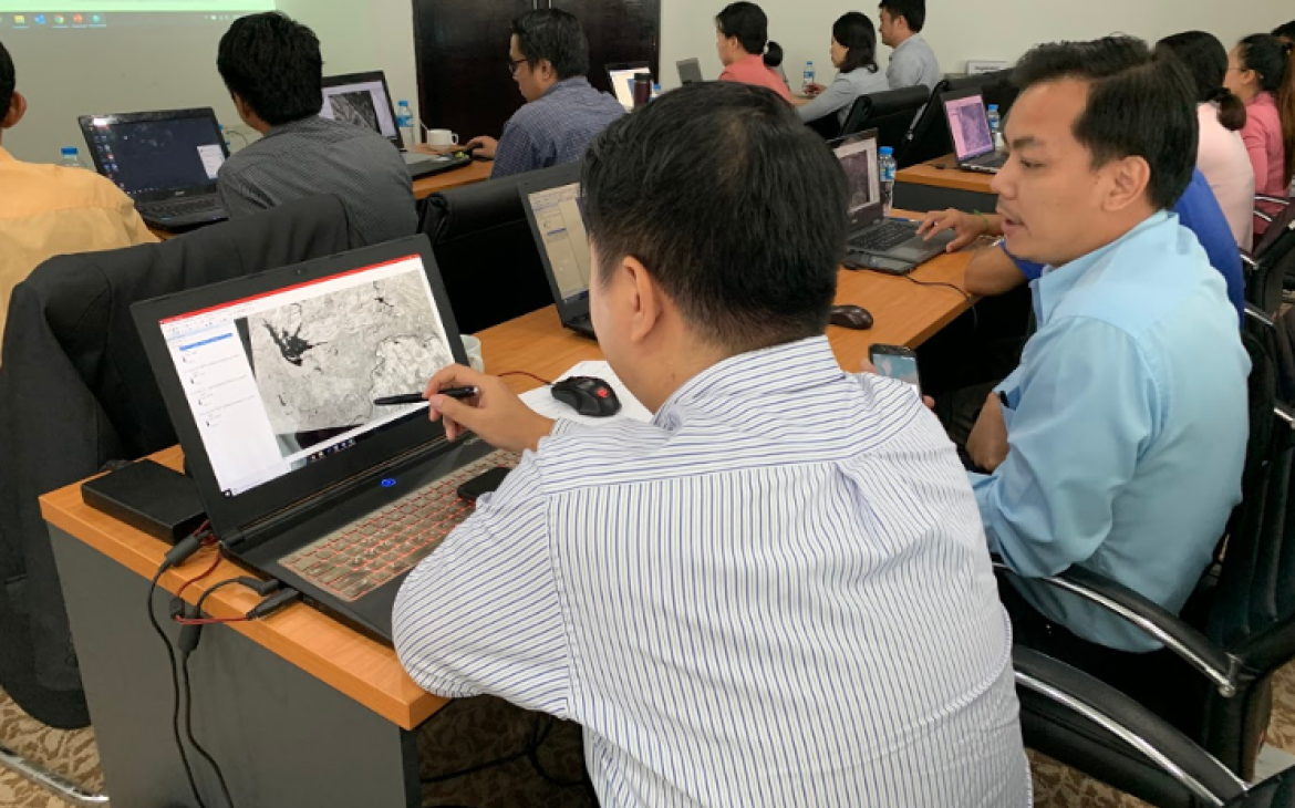
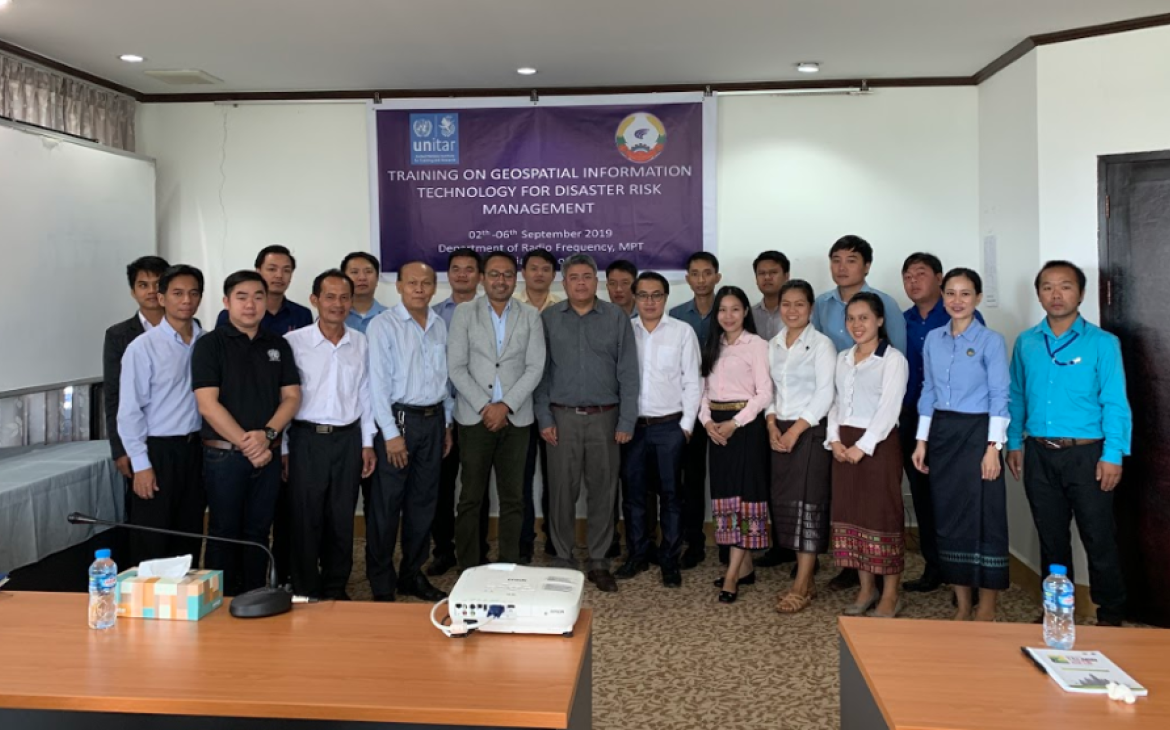
Naturally following the progression of UNOSAT’s rapid mapping services and technical backstopping activities in 2018, UNOSAT and Lao PDR’s Ministry of Post and Telecommunications jointly organized a 5-day introductory training between 02 and 06 September 2019, for Lao government officials in the country’s capital, Vientiane. The event, “Introduction to Geospatial Information Technology for Disaster Risk Management” aimed to build participants’ capacities in the use of GIT for DRR, marking the first time UNOSAT delivered a training workshop in Lao PDR.
This training was designed to provide participants with a theoretical understanding of elementary principles of GIS and Remote Sensing (RS), including how to perform basic spatial analysis, collect data using GPS or smartphones and solve DRR problems by developing decision support tools. Participants were enthusiastic about the course, with one stakeholder commenting “It is useful for our [team] to learn new technology. It is important for Lao people”. Another participant requested, “I want a follow-up course because it is very interesting and useful for my work”.
On-Site Support to the Disaster Management Department
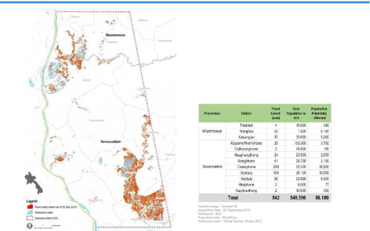
During the training, a participant from Lao PDR’s Department of Disaster Management of the Ministry of Labour and Social Welfare requested UNOSAT’s support for the monitoring of ongoing floods in the southern provinces of the country. This illustrated the efficacy of UNOSAT’s awareness-raising on the need and uses of GIT in disaster situations. It also gave an opportunity for training participants to apply the principles taught during the week and showcase the utility of such practices.
Additionally, through the on-site support, UNOSAT gathered and analyzed data to perform a rapid assessment of flooding in the target area. The government deemed the results to be very useful and acknowledged UNOSAT’s contribution to its disaster management operations.
Training Participant Using Training Knowledge for Drainage Survey in Ventiane
Early results from UNOSAT’s trainings have already been witnessed, as a few participants have already begun to apply the knowledge acquired from the course. Ms. Phayvone Sengphone, a technical officer working for the Remote Sensing and Information Division of the Ministry of Natural Resource and Environment (MONRE), has relayed that the training has helped hone her skills in GIS data and satellite imagery sourcing and downloading – in addition to equipping her to regularly use Sentinel-1 to extract flood extent data and routinely apply UN-ASIGN in her work.
Since the training, Phayvone has been applying UN-ASIGN for data collection in the field on two projects she initiated. The first project is a wastewater drainage condition survey in Vientiane city, which manifested after she realized the potential of using smartphones to collect and geotag photos and information to modernize her department’s existing surveys. She has expressed her contentment on how smoothly this new approach has worked and has even proposed her office to apply UN-ASIGN for collecting the connection points of canals in the municipality. This has additional benefits as the Chinese government will allocate two wastewater treatments to Lao PDR, with MONRE carrying the responsibility of assigning suitable sites for their installation.
Her second project involves risk assessments for earthquake hazards. The MONRE has used satellite images to locate fault lines and process risk analyses for villages surrounding the fault area. Phayvone says that UN-ASIGN has been applied for collecting village locations during the field study.
When asked about the benefits of UN-ASIGN, Phayvone replied that the system is super convenient and there is no need for expensive GPS handheld devices while surveying areas. Additionally, she has commended the system’s ability to work well while offline or without signal really made survey possible in remote locations. Her boss has also recognized the benefits of using the system and has recommended that it be used in their next project on conducting a risk assessment in Xayaburi Dam next year.
UNOSAT will continue to be in touch with her to provide further technical support and better customization of the field data collection and data visualization tools.
Future Needs of Stakeholders: Interviews with Disaster Management Officials
Through additional interviews with government stakeholders that participated in the technical training, immediate-term outcomes, in regard to enhanced knowledge and skills, were similarly visible and attributable to the workshop.
Mr. Phonesavanh Saysompheng, of the Ministry of Labour and Social Welfare in Lao PDR, relayed that prior to the course capacity to use geospatial solutions for DRR was not high in his office, but that because of the training they feel better equipped to use, produce and analyse digital maps to make DRR plans, further explaining that he would be interested to use his skills in assessing areas to rebuild after floods.
Although such short-term capacities are promising, it will take time to ensure lasting impact. For this reason, follow-up consultations were conducted to assess additional contextual needs. Due to the tropical climate and the unique topographic characteristics, Lao PDR is exposed to a range of natural hazards that often result in disasters, with floods being the major contributor. More than 80 percent of the country’s population live in rural areas, of which two-thirds rely on agriculture – a sector extremely vulnerable to floods.
In recent years, Lao PDR has been experiencing devastating flash floods on a nearly annual basis. UNOSAT has provided rapid mapping services for both 2018 and 2019 flooding events, however, the post-disaster information could not bring sufficient value in terms of reducing losses. It has also proven difficult to obtain satellite images at precise times due to the short duration of flash flooding.
Lao PDR already has a national portal established for early warning systems (EWS), including SOPs for the Department of Meteorology and Hydrology (DMH) under the Ministry of Natural Resources and Environment (MoNRE). This specific EWS provides monitoring information on current water level and rainfall in two river basins, Sebanghiang and Sabangfai, but currently, no functionality exists for providing timely and actionable information to the authorities and communities.
Additional departments have sought UNOSAT’s expertise. The Department of Disaster Management (DDM), under the Ministry of Labour and Social Welfare (MoLSW), is the mandated agency responsible for disaster response. In this regard, DDM has expressed to UNOSAT their need to receive flood forecasting with 3-7 days lead time at the district or community level. For their operational purpose, it is vital that they obtain information on the extent of flood levels that may occur, to determine potential impacts on people and property. The DDM has conveyed their commitment to modernizing their DRR operations based on data and evidence, however, they have commented that their lack of resource personnel is hindering their progress.
Request from Lao Government: Earthquake Exposure Map
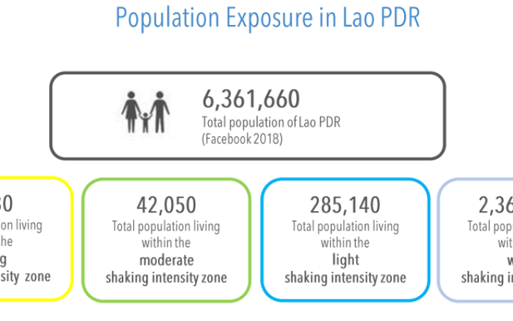
On November 21, 2019 at 06:50am (UTC+7), a 6.1 magnitude earthquake at a depth of 3km occurred 20km southeast of Ban Nam Chang, Nan Province in Lao PDR. Within the first 24 hours, UNOSAT’s Rapid Mapping Service provided the Lao government with a population exposure analysis. The Lao PDR National Disaster Management Office (NDMO) soon reported that the affected areas comprised eleven districts in Xayaboury province with the most damages in Hongsa and Xaysathan districts, comprising 34 villages. The NDMO further estimated damages from the earthquake to amount to $278,874 USD.
Such disasters highlight the need continue to capacity building efforts to further equip technical experts with the information and skills not only on hazards related to floods, but also with the tools so they can prepare for any disaster situation and implement GIT informed emergency response plans.
Looking Back and Looking Forward
During the 2017-2019 project period, UNOSAT has created 27 rapid mapping products for partners and stakeholders in Lao PDR, covering floods, tropical cyclones, and an earthquake. As for capacity building, UNOSAT’s first in-country technical training in Lao PDR benefitted 22 stakeholders from 11 different ministries. This project has presented UNOSAT with opportunities to leverage its internal capacity for critical technical trainings and rapid mapping aimed at enhancing recovery efforts and DRR activities. Going forward, it is imperative that UNOSAT with the support of donors keeps investing in the continued capacity development of the national stakeholders in Lao PDR to fully take advantage of the cutting-edge geospatial technologies for smarter DRR interventions.
For more information, contact UNOSAT at unosat@unitar.org.


