Enhancing Sri Lanka’s Capacity in Integrating Earth Observation Applications for Urban Disaster Risk Reduction (URBANDRR)
 14 September 2016, Colombo, Sri Lanka – UNITAR’s Operational Satellite Applications Programme (UNOSAT) in collaboration with the National Building Research Organisation (NBRO) of Sri Lanka conducted a successful two-day training programme on “Integrated Satellite Applications for Urban Disaster Risk Reduction” focusing on flood and landslide risk mapping. The aim of the training programme was to enhance the capacity of disaster management professionals working on pre- and post-disaster interventions using geospatial applications, including Unmanned Aerial Vehicles (UAVs, also known as drones). The training programme was held at the premises of the Regent Country Club, Malabe and Dons Lake Resort, Avissawela on 1 and 2 September 2016, respectively.
Opening Remarks by ADPC Special Adviser
In the opening remarks, Mr N.M.S.I. Arambepola Special Adviser to Asian Disaster Preparedness Center (ADPC) stated that:
"If we are still implementing disaster risk reduction the way we used to do 10 years before, then obviously we are not doing it right. It is high time we harness the power of modern technology not only for DRR but also for all the aspects of 2030 Agenda."
He also emphasized on the importance of using new technologies for better understanding of risks as well as intelligent preparedness measures.
Methodology and Vulnerability Data Collection
 Participants were presented with the URBANDRR concepts and requirements (in-terms of higher detailed exposure, vulnerability and elevation models) using highly interactive computer-assisted exercises based on real case scenarios derived from recent disasters in the region. They were also made familiar with Smartphone based data collection systems (using UN-ASIGN), a UAV based data collection planning system, UAV-ASIGN and UAV-Pilot for coordination of UAV flights. They were then divided into groups and the participants were assigned tasks of collecting real time data on vulnerability, exposure and historical hazard record from the field. Once this ground data collection was completed, UAV’s were taken in to the field. The pilot was flying the UAV and a co-pilot was continuously in-touch with the remote expert team in Geneva who provided guidance for a more reliable and comprehensive aerial survey through live chat.
UAV Based Aerial Survey
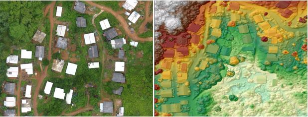
For the purpose of creating a high quality basemap and a digital surface model, a double grid aerial mission was planned; for an area of 300m X 300m the mission took 12 minutes and safely landed by auto-pilot. Later on the image was processed using pix4D to produce a 4cm resolution ortho-mosaic and a digital surface model. At the end of the field mission, participants were briefed using the real-time results. Participants were impressed by the applicability of the presented solutions that resulted into valuable inputs for future handling of hazards and risks. The field operations were closely monitored by the National Building Research Organization (NBRO) head-quarters who was impressed at the ability to observe the live operations.

The URBANDRR project is an important step in the developing capacities of governments in the use of geospatial technologies for ongoing disaster risk activities. The project is coordinated by AnsuR Technologies and financed by the European Space Agency (ESA).
Photo 1: Participants during the field data collection exercise with UNOSAT’s expert Mr. Khaled Mashfiq explaining data collection procedures
Photo 2: UNOSAT’s remote expert in Geneva monitoring incoming observations and communicating live with drone co-pilot
Photo 3: The higher spatial detail ortho-mosaic and the shaded relief of corresponding generated digital surface model

