Satellite-Based Analysis Across the Disaster Management Cycle
21 November 2025, Praia, Cabo Verde- In August 2025, severe storms struck three islands in Cabo Verde. Many affected communities were physically cut off due to the collapse of roads and sections of roads and unstable slopes. The lack of up-to-date local data due to limited access made it difficult to quantify the scale of damage.
In this context, the United Nations Satellite Centre (UNOSAT) Emergency Mapping Service, in close coordination with national and local authorities, including Cabo Verde Civil Protection and municipal authorities and NGO’s, provided critical support across the entire disaster management cycle, from immediate emergency response through operational decision-making to long-term recovery planning, respecting the principles of inter-institutional coordination and complementarity
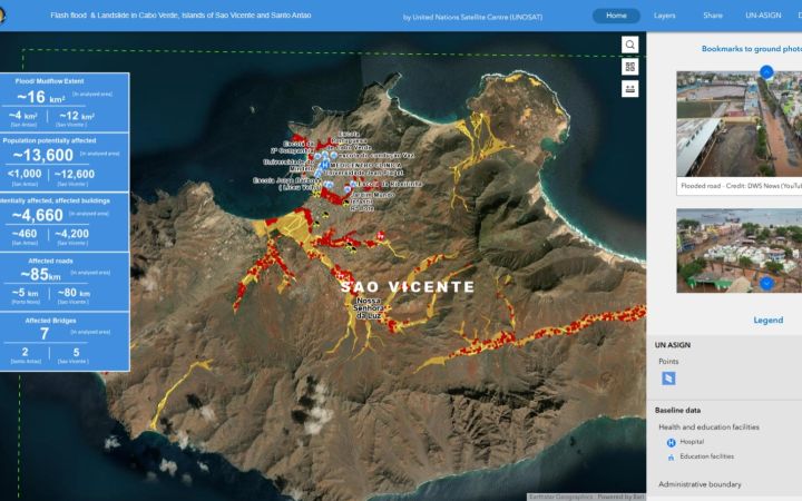
UNOSAT identified over 4,000 infrastructure elements affected, including both public infrastructure and private buildings. UNOSAT products also documented damage to cultural and natural heritage, including 45 instances of damage or possible damage[1] to traditional terraced agricultural fields, irrigation systems, and heritage pathways. The damage detected included damage to the gravity-based irrigation system controlling waterflow to Cruzinha Natural Park. Damage to the island's irrigation system resulted in local flooding[2].
Rapid Emergency Response
Communication lines were established immediately after the emergency response activation. OCHA's regional office in Dakar, which had a long-standing collaboration with UNOSAT from supporting previous disasters in the region, made the connection with local stakeholders, including the UN Resident Coordinator's office.
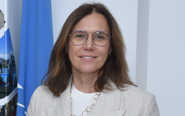
The first map-just to situate in terms of data, we got approximately two days after the initial request, explained Ms. Patricia Portela de Souza, UN Resident Coordinator for Cabo Verde.
UNOSAT produced high-resolution maps showing the spatial extent of floods and landslides, focusing on Mindelo city, where damage was most severe. The maps provided a quantified overview of the areas most affected.
In a context where ground access was extremely limited, this analysis provided the only comprehensive visual assessment available during the first week of the crisis, Patricia noted.
I would say the first two weeks of the crisis, we were totally counting on this (UNOSAT geospatial products).
The UNOSAT team also worked in close collaboration with multiple UN agencies, including OCHA, WHO, UNICEF, UN-Habitat, UNDP, UNESCO, FAO, and IOM, which jointly conducted rapid assessments with government and municipal authorities across the three affected islands.
Supporting Operational Decision-Making
Information gaps hindered coordination between national authorities and partners. Many affected communities were physically isolated due to collapsed roads and unstable slopes.
Satellite-based data and mapping became critical and pivotal to the response, because they provided an initial objective overview of the disaster's impact and guided decision-making on the ground for both emergency relief and later on the post-disaster needs assessment process,
Patricia emphasized.
The flood and landslide maps were used to identify the most affected areas and prioritize deployment of limited resources. Updated maps and imagery analysis were subsequently provided on a regular basis.
Having reliable, especially consistent data, reduced duplication and improved efficiency, that's the way we analyze it. The team was, and I really appreciated, very flexible in adapting the products to the needs that we had on the ground.
said Patricia.
During coordination meetings with the UN task force, OCHA, and UNOSAT, the maps were referenced multiple times to inform government, municipalities, and non-governmental organizations working on the ground.
Post-Disaster Planning and Recovery
Beyond immediate emergency response, UNOSAT products proved valuable for post-disaster planning. The National Institute of Land Management used flood and landslide maps to overlay satellite data with the National Register System, enabling initial estimation of damage to housing and infrastructure.
By combining UNOSAT maps with census microdata from the Cabo Verde National Statistics Institute, including building typologies and construction materials, a more detailed spatially disaggregated picture of housing impact was developed.
We're still using the information that we get from colleagues from UNOSAT, this integrated approach allows the identification of structural vulnerabilities and supports the design of recovery interventions that are better targeted and also in a more equitable manner.
Patricia noted.
The Government of Cabo Verde declared a situation of calamity and adopted a strategic response and recovery plan. A national framework for post-disaster recovery and resilience was endorsed by the Council of Ministers with a total budget of USD 42.6 million.
The figures and the image and the data that we got from colleagues from UNOSAT were essential to feed into this major policy response and the immediate response that was done up front,
Patricia stated.
UN Habitat, leading the housing sector within the post-disaster needs assessment, maintains direct contact with the National Statistics Institute and UNOSAT colleagues. The UNOSAT products feed the National Recovery Plan, which encompasses short-term, medium-term, and long-term actions.
Cost-Effectiveness and Value
UNOSAT's intervention in Cabo Verde has demonstrated clear cost-effectiveness in terms of the type of support that was provided and the high use of the products. In a situation where direct field assessments were very limited, and also costly and time-consuming, satellite imagery analysis provided rapid and reliable data at a minimal additional cost. Patricia explained
In the specific case of Cabo Verde's affected islands, UNOSAT benefited from cloud-free conditions immediately after the storm when satellites were passing overhead, allowing the use of high-resolution optical data. However, radar satellites would not have been deployed if clouds had prevented optical imagery acquisition.
Partnership and Collaboration
The collaboration proved highly effective due to established networks and ongoing communication.
For me, UNOSAT represented an excellent example of the best practice in terms of cooperation. It was a joint effort involving Cabo Verde, Dakar and Geneva, all interconnected at different points, working in coordination to support this small country that was suffering,
Patricia reflected.
Communication lines remained open throughout the emergency response and into the recovery phase. The UN Country Team now recognizes this capability and understands how to leverage UNOSAT's support for future emergencies.
On behalf of the UN Country Team in Cabo Verde, we expressed our sincere appreciation to UNOSAT, to NORAD, that supports UNOSAT, and we believe that this partnership has strengthened our collective ability as a UN Country Team, but also civil protection colleagues, to respond effectively to disaster and to plan, recover in a way that builds resilience for a near future,
Patricia concluded.
UNOSAT's comprehensive support to Cabo Verde demonstrates the critical value of satellite-based analysis across the full disaster management cycle. The case illustrates how geospatial information, when delivered rapidly and adapted to user needs, becomes essential for evidence-based humanitarian action and strategic policy development.
Learn more on www.unosat.org


