Tropical Cyclone Idai made landfall during the night of 14 to 15 March 2019 near Beira, a low-lying city of 500,000 residents in central Mozambique, before moving inland to neighbouring Zimbabwe and Malawi. The cyclone brought winds of up to 177 km/h (106 mph) and torrential rains that caused rivers to burst over their banks and submerge streets and homes across several provinces in Mozambique. Governmental officials described the damage as "massive and horrifying" while IFRC and UN officials described seeing “water and water for miles and miles” and “90 percent of the Beira city completely destroyed.”
UNITAR’s UNOSAT Unit, upon the request of several UN humanitarian agencies (i.e. UNOCHA, WFP, UNICEF, FAO and UNHCR), immediately began carrying out rapid assessments of damage using available satellite images covering affected areas.
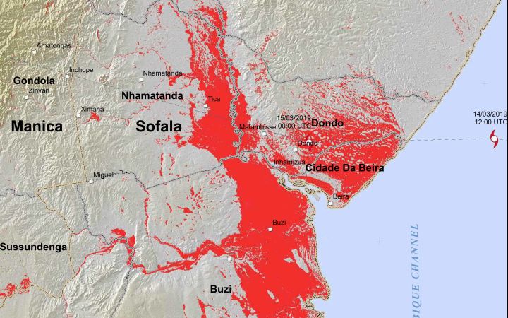
Based on preliminary assessments, UNOSAT confirmed the reported magnitude of devastation by estimating that more than 1.6 million people were living in the direct path of the cyclone and therefore had been potentially affected.
On 16 March, Cyclone Idai continued across land as a tropical storm and hit eastern Zimbabwe. The cyclone caused flash flooding, which has subsequently led to deaths and the destruction of livelihoods and properties in Chimanimani and Chipinge districts.
The full impact of the cyclone is yet to be established. However, according to UNOCHA (as of 29 March 2019) the death toll across Mozambique, Zimbabwe and Malawi was at least 700, with hundreds of people still missing and nearly 141,000 people displaced. The cyclone destroyed entire towns and villages, and wiped out hundreds of thousands of hectares of farmland on the eve of the next harvest. According to the World Meteorological Organization, this is one of the worst weather-related disasters — and specifically one of the worst tropical cyclone-related disasters — in the Southern Hemisphere.
Aerial assessments of the Buzi Valley, west of Beira and along the Buzi River, “showed entire villages wiped out.”
In line with our continuous efforts to help achieve the goals of the Agenda 2030, and specifically SDG 13 (take urgent action to combat climate change and its impacts), UNOSAT continues to provide support to Mozambique, Zimbabwe and Malawi Governments, and to all humanitarian agencies involved in relief and rescue as well as emergency response operations. In less than two weeks, UNOSAT’s team has analysed more than 170,000 km² and estimated more than 17,000 km² of flood-affected land.
Faced with enormous challenges like power outages and the difficulty of obtaining necessary data in the midst of an emergency of this scale, humanitarian agencies found that satellite imagery analysis provided by UNOSAT was critical to gaining an overall picture of the devastation across the three affected countries.
Satellite derived analysis timely provided allowed for evidence-based decision making among responding agencies, was used to verify initial infrastructure damage in Beira, and was integral to assessing the flood situation over remote communities not accessible by humanitarian aid agencies. The data and analyses will also be useful for subsequent recovery and development efforts, as well as disaster risk reduction planning for future tropical cyclones. UNOSAT is also available to build national capacities in the use of satellite imagery for climate change adaptation and disaster risk reduction.
“Our field teams have an ongoing need for the latest flood extent data, specifically, at the moment, for planning helicopter and road assessments. So your map and data products are very timely and helpful” (United Nations Disaster Assessment and Coordination Team – UNDAC)