
20 December 2012, Bangkok, Thailand - During intergovernmental meetings being held this week at the United Nations Economic and Social Commission for Asia and the Pacific (ESCAP), countries from the Asia-Pacific region are showing that their awareness and use of geospatial information to reduce the risk of natural disasters and be better prepared to respond to emergencies is growing steadily. UNITAR operations and capacity development offer through UNOSAT have an important role in this process.
In this region that holds the record of the highest number of people affected by natural disasters, UNOSAT has been working since 2010 within a sub-regional programme funded by Norway to deliver advanced training and help national agencies make the most of satellite derived analysis and mapping in the face of growing vulnerability to natural hazards. In addition, since 2003 the UNOSAT Humanitarian Rapid Mapping Service has been activated tens of times in support of international emergency relief operations in the region. In December 2012 alone, the service has been used three times already in this region.
The engagement of UNITAR/UNOSAT in supporting Asia-Pacific countries is being rewarded not only by success but also by increasing official recognition. Both the meeting of the Intergovernmental Consultative Committee on the Regional Space Applications Programme for Sustainable Development and the Intergovernmental Meeting on Asia-Pacific Years of Action for Applications of Space Technology on GIS for Disaster Risk Reduction and Sustainable Development, have provided positive feedback on the work of UNOSAT. ESCAP itself, the only UN economic commission equipped with GIS and space applications competencies, says it is “making efforts to enhance the partnership with UNITAR on capacity development for more effective utilisation of satellite imagery in disaster risk management”.
Francesco Pisano, who participated in the meetings, says: “It is important for us to know that the financial and time investment we have made in the region in terms of research and applications is helping real people solve real problems. While we will continue to provide emergency rapid mapping in collaboration with OCHA and national disaster management agencies, we are shifting gears on capacity development, advanced training and technical assistance. We think that ESCAP is the right partner for the UNOSAT capacity development programme in this part of the world”. On this subject Pisano had bilateral discussions with the Executive Secretary of ESCAP, Under-Secretary General Noeleen Heyzer. “We agreed to work to maximise UNITAR and ESCAP respective comparative advantages and to deliver more and better throughout the region”.
Countries of the region fully understand the benefits and limitations of satellite applications. They say that they now need capacity development options, specific training and technical coaching to select the best combination of technology among those available today. “There are many workshops, many discussion fora, and many efforts to provide access to more and more imagery, to demonstrate that satellite technology is increasingly available and increasingly useful. But when you sit with a national technical agency in charge of a specific job, they will tell you the challenge is to know how to develop the technical and human resources needed nationally and locally to be able to benefit from all this” says Pisano. “We work to try to respond to this need and we like to do this in partnership with the other UN agencies and offices who have their own output to deliver so that together we can help better”.
Photo 1: From right to left, the Executive Secretary of ESCAP, the Minister of Science and Technology of Thailand, and the Director of the ESCAP Division in charge of ICT, Disaster Risk Reduction and Space Applications.
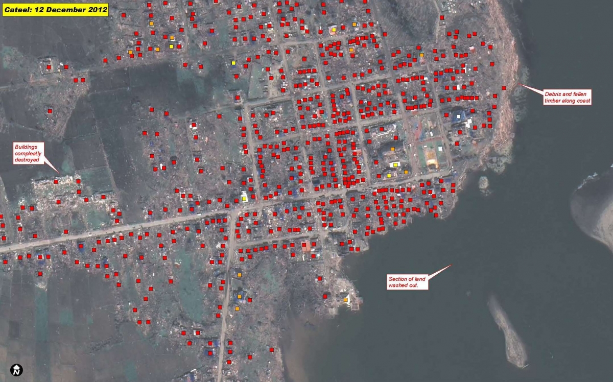
Photo 2: Detail of UNOSAT satellite damage assessment over the area affected by Cyclone Pablo/Bopha in the Philippines.