

 19 May - Bern, Switzerland - Invited as a guest lecturer on the occasion of the 9th meeting of the Advisory Group on Environmental Emergencies, UNITAR Executive Director, Carlos Lopes, addressed the issue of environmental disaster response and, more specifically, opportunities that new technologies create in the area of disaster risk reduction as well as related capacity building efforts. Mr Lopes brought UNITAR’s perspective to the discussion by highlighting the importance of capacity development, effective partnerships and the key role of high-quality training methodologies for effective environmental emergency response.
UNITAR’s work in the area of emergency response has received a broad appreciation, and its Operational Satellite Applications Programme, UNOSAT, is a recognized centre of excellence for satellite analysis. In this context, the Executive Director indicated that there is a window of opportunity to further develop cooperation between the AGEE and the Joint UNEP/ OCHA Environment Unit, on the one hand, and UNITAR, on the other. This can also contribute to building stronger capacities like the Environmental Emergencies Center.
The AGEE, established in 1995 at the recommendation of member states, is an inter-governmental consultative mechanism bringing together disaster managers and environmentalists from developed and developing countries to share ideas and experiences on global environmental emergency response, and to advise on and review the work of the UNEP/OCHA Joint Environment Unit. The UNEP/OCHA Joint Environment Unit was created one year earlier, in 1994, as a special international tool to respond to environmental emergencies based on existing disaster response mechanisms and integrating UNEP’s environmental expertise.
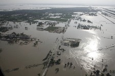
UNITAR’s partnership with the Joint Environment Unit goes back to 2004, when its satellite programme UNOSAT provided maps during the uranium mine collapse in DRC, and most recently the mass acute lead poisoning in Nigeria. UNOSAT’s work for emergency response, humanitarian relief, coordination and environmental emergency response consists in providing vital geographical information and timely satellite imagery analysis for rapid and effective decision making and situational awareness over areas that cannot be easily accessed. Satellite imagery complemented by local field surveys has been particularly useful in emerging countries that often have poor geospatial information and in some cases outdated maps. This information enables local institutions, among other actors, to produce actionable knowledge on the various risks facing vulnerable communities, and serves to improve urban and rural territorial management as well as to time-stamp the environmental situation at certain intervals to monitor environmental parameters, such as forest cover and urbanisation trends.
The 9th AGEE meeting took place in Bern on 19 May, in the presence of the outgoing and newly elected AGEE Chairs Ambassador Frisch, Mr. Larsson, and other AGEE participants, as well as Director of the UNEP Division of Environmental Policy Implementation Mr. Thiaw, OCHA-Geneva Director Mr. Khalikov, the Chief of the OCHA Emergency Services Branch, Mr. Muller, and the Chief of the Joint UNEP/ OCHA Environment Unit Mr. Sakharov.
(Photo credit: UN Photo – E. Schneider)