

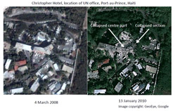
The earthquake that rocked Haiti on Tuesday this week caused unprecedented consequences on the population and the urban areas of Haiti. Many United Nations staff and peacekeepers remain unaccounted for in Haiti, and many are reported to be trapped in UN buildings that collapsed in the earthquake, UN officials say. A former UNITAR staff member was among those present in the UN building at the time of the quake.
Upon request by several agencies, UNITAR has mobilised the UNOSAT programme to support immediate response and early recovery planning with satellite derived maps and analyses. UNOSAT, which operates a 24/7 humanitarian rapid mapping service since 2003, works in cooperation and coordination with several other entities worldwide that are doing their best to produce adequate geospatial information to facilitate emergency response in Haiti.
With the support of the US Government and the French Space Agency CNES, UNOSAT is producing information according to the specific needs of a number of users on the ground, while a variety of general mapping products are becoming available from the private sector and several geographic services and entities. The International Space Charter is also part of the global effort being deployed at this time. UNOSAT is also working in partnership with Google.
To read more about satellite derived geographic information in relation to this disaster click here
To view the map produced by UNOSAT, click here